I didn't get very far today only a little over 200 miles, but it was a good day I took a swing through the June Lake Loop just north of Mammoth Lakes because my friend Liz camps there every year. To find the exact spot I called her on my cell and she talked me through. It was fun to take this "trip" with her as she pointed out things I might not have noticed. Then back onto Hwy 395 north, admiring the snow capped mountains and even the non-snow capped ones. I haven't driven north of Bishop for quite a few years and things have certainly changed. There is much more civilization along the way with small towns now grown to medium towns and a new perimeter freeway around Carson City and on the east side of Reno. No longer a need to drive right through the middle of town. I did drive the business route through Carson City and found it rather sad as many businesses have gone away due to the lack of traffic, I expect. Gardinerville has grown so much I didn't recognize a thing and the highway becomes a freeway just to the north.
I was feeling a little at sea and OLD because things are so different and I remembered that Beth told me that the Reno Art Museum was worth a visit. I enjoyed it very much, but told the desk person when I left that they need to provide more benches for old ladies who can't stand for hours at a time. Nice gift shop, They were setting up for a special event tonight so several galleries were closed, but they have some great paintings, sculpture, and photography. It is a large building with great high ceilings and wide corridors. By the time I was finished looking it was about 4:30pm and I decided not to drive on, booking a room at Holiday Inn Express in Reno. It is a much larger facility than a lot of HIEs I have stayed previously. The check-in was cold and a little snippy and once again I couldn't have a room on the first floor, but it isn't quite in the middle of the second floor - thank heavens.
I took a rest and watched a BBC rerun of the wedding. Very elaborate and lots of fanfare, I enjoyed it more than if I had sat through the entire thing. I wish them well, I think they will have a hard life together. Waaaay too much spotlight for me.
Here are pictures from today.


Motel room - just like a million others!

Leaving Bishop still following along the east slope of the Sierra.

Mountain tops were covered with clouds, wonder if they had more snow.

Lots of cloudy skies, but no rain along my route.

This is not an Interstate highway, so there are bikers and guys parked where the fishing is good.

This mountain stands alone. Maybe it is Mammoth.

TREES! You may have noticed there are many in the previous pictures. These are mostly Ponderosa pines which appear at certain elevations. I think it is more than 4000 feet.

From the Silverlake Campground that Liz loves one can see this waterfall, high on the mountain. the house is an old one that the owner is renovating in hopes of having a B&B some day.

This is the Silverlake campground with the mountains towering overhead.

When I drove on north on the June Lake Loop I realized I should have used the facilities, so I stopped at this campground along the stream. Notice it is almost unoccupied? There are no hook ups! I think the majority of campers enjoy the amenities of their RVs and trailers.

And there is no brilliant waterfall coming down the mountain - this is the sunny side and the snow is long gone.

Nice clean, flush bathroom. Ahhhh.

Where the Tioga Road turns off to Yosemite (the pass is still closed by snow) there is a Mobil station that has a restaurant of some fame. I don't know if it is the same chef as a decade or so ago, but the food it excellent if pricey. They don't serve continuously - lunch today didn't open until 11am. But I'm pretty sure they serve breakfast early in the morning. Check it out.

This is the view from the patio out over the Owens Valley.

Just beyond the turnoff is the tiny village of Lee Vining. I have stayed there on occasion, it is really just a wide spot in the road with motels and restaurants and fishing supplies and tourist stuff.

At the end of the town there is a highway advisory sign that usually would give road conditions. But here they are warning of deer. I didn't see any, but they are more common in the evening.

This is looking south at Owens Valley, part of the great basin. Notice the road on the right.

Along the north side of Owens Lake the road is treacherous due to rock slides. Notice the cement barrier which stops most of the rocks.

But they have added heavy duty cyclone fencing and heavy duty cables. It is a scary place, some of the rocks on the hillside are as big as cars.

Just a bit further north there is a vista point on the southbound side of the highway. If you go up about a mile there is an intersection where you can turn around and go back to take a look. There are explanatory placards explaining the Great Basin and how it was formed.
Notice that skinny road again, right in the middle.

There is the "gold standard" - just to prove I was there.

Some people think stickers are suitable anywhere. I think it is a disgrace - ugly.
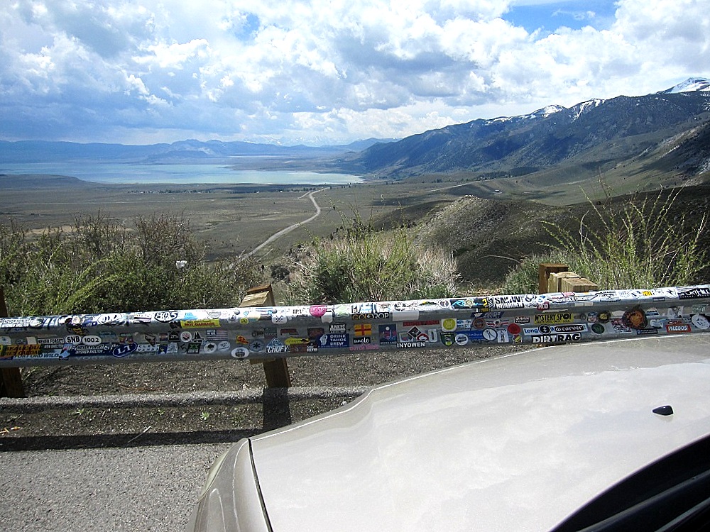
Quite a view. And that little road? It is highway 395 - far, far below.

The Walker River is roaring and splashing right now from snow melt. But I could not find a clear spot to photograph it. Guess I should have pulled over, eh?
# # #


No comments:
Post a Comment