Showing posts with label Bishop. Show all posts

Saturday, May 19, 2018

Road Trip - Bishop to Reno, NV 05-19-18

I didn't get very far today only a little over 200 miles, but it was a good day   I took a swing through the June Lake Loop just north of Mammoth Lakes because my friend Liz camps there every year.  To find the exact spot I called her on my cell and she talked me through.  It was fun to take this "trip" with her as she pointed out things I might not have noticed.  Then back onto Hwy 395 north, admiring the snow capped mountains and even the non-snow capped ones.   I haven't driven north of Bishop for quite a few years and things have certainly changed.  There is much more civilization along the way with small towns now grown to medium towns and a new perimeter freeway around Carson City and on the east side of Reno.  No longer a need to drive right through the middle of town.  I did drive the business route through Carson City and found it rather sad as many businesses have gone away due to the lack of traffic, I expect.  Gardinerville has grown so much I didn't recognize a thing and the highway becomes a freeway just to the north.  

I was feeling a little at sea and OLD because things are so different and I remembered that Beth told me that the Reno Art Museum was worth a visit.  I enjoyed it very much, but told the desk person when I left that they need to provide more benches for old ladies who can't stand for hours at a time.  Nice gift shop,  They were setting up for a special event tonight so several galleries were closed, but they have some great paintings, sculpture, and photography.  It is a large building with great high ceilings and wide corridors.  By the time I was finished looking it was about 4:30pm and I decided not to drive on, booking a room at Holiday Inn Express in Reno.  It is a much larger facility than a lot of HIEs I have stayed previously.  The check-in was cold and a little snippy and once again I couldn't have a room on the first floor, but it isn't quite in the middle of the second floor - thank heavens.  

I took a rest and watched a BBC rerun of the wedding.  Very elaborate and lots of fanfare, I enjoyed it more than if I had sat through the entire thing.  I wish them well, I think they will have a hard life together.   Waaaay too much spotlight for me.  

Here are pictures from today. 
Motel room - just like a million others!

Leaving Bishop still following along the east slope of the Sierra. 

Mountain tops were covered with clouds, wonder if they had more snow. 

Lots of cloudy skies, but no rain along my route.

This is not an Interstate highway, so there are bikers and guys parked where the fishing is good. 

This mountain stands alone.  Maybe it is Mammoth. 

TREES!  You may have noticed there are many in the previous pictures.  These are mostly Ponderosa pines which appear at certain elevations.  I think it is more than 4000 feet. 


From the Silverlake Campground that Liz loves one can see this waterfall, high on the mountain.  the house is an old one that the owner is renovating in hopes of having a B&B some day. 

This is the Silverlake campground with the mountains towering overhead. 

When I drove on north on the June Lake Loop I realized I should have used the facilities, so I stopped at this campground along the stream.  Notice it is almost unoccupied?  There are no hook ups!  I think the majority of campers enjoy the amenities of their RVs and trailers.


And there is no brilliant waterfall coming down the mountain - this is the sunny side and the snow is long gone. 

Nice clean, flush bathroom.  Ahhhh. 

Where the Tioga Road turns off to Yosemite (the pass is still closed by snow) there is a Mobil station that has a restaurant of some fame.  I don't know if it is the same chef as a decade or so ago, but the food it excellent if pricey.  They don't serve continuously - lunch today didn't open until 11am.  But I'm pretty sure they serve breakfast early in the morning.  Check it out. 

This is the view from the patio out over the Owens Valley.  

Just beyond the turnoff is the tiny village of Lee Vining.  I have stayed there on occasion, it is really just a wide spot in the road with motels and restaurants and fishing supplies and tourist stuff.  

At the end of the town there is a highway advisory sign that usually would give road conditions.  But here they are warning of deer.  I didn't see any, but they are more common in the evening. 

This is looking south at Owens Valley, part of the great basin.  Notice the road on the right. 

Along the north side of Owens Lake the road is treacherous due to rock slides.  Notice the cement barrier which stops most of the rocks. 

But they have added heavy duty cyclone fencing and heavy duty cables.  It is a scary place, some of the rocks on the hillside are as big as cars. 

Just a bit further north there is a vista point on the southbound side of the highway.  If you go up about a mile there is an intersection where you can turn around and go back to take a look.  There are explanatory placards explaining the Great Basin and how it was formed. 
Notice that skinny road again, right in the middle.  

There is the "gold standard" - just to prove I was there. 

Some people think stickers are suitable anywhere.  I think it is a disgrace - ugly.
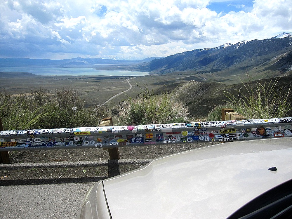
Quite a view.  And that little road?  It is highway 395 - far, far below. 

The Walker River is roaring and splashing right now from snow melt.  But I could not find a clear spot to photograph it.   Guess I should have pulled over, eh? 
#   #   #

Tuesday, May 15, 2018

Road trip prep 05-15-18

I always leave too much to the last minute.  I was looking at my maps last night and find that my Oregon and Washington maps are quite a few years old.  So, now I must stop at AAA to pick up some new ones.  Why didn't I think of this a month ago?   Yes, I do have Google maps, Map Quest, WAZE, and even a built in electronic map system in my car.  But I like to see what is around me, I know where I am going and could drive it without a single map.  As I am driving I see mountains (what are they called?), and valleys which must have a name, and little crossroads that turn off to where?  It is part of loving a road trip.  Sometimes, when time allows I will turn off and take a scenic route, or even a non-scenic route, just to see somewhere different.  

I have given some thought to turning off in Bishop and driving up into the mountains where Floyd and I went fishing several times a year.  Bishop Park was our favorite campground and we always strove to nab the campsite at the very top of the road under an enormous Jeffrey pine.   The campgrounds don't open (or didn't used to) until after Memorial Day, so I could only go to the gate.  Depends on how tired I am, I guess.  I've been up there a half dozen times in the last 28 years, just to sit and remember what wonderful times we had..  I guess I'll wait until I get there and see how I am doing.  

These pictures were taken in October 2012.

It is a beautiful drive up, up, up into the mountains. 

Here is our favorite campsite.

Looking up into the huge Jeffrey pine. 

And about 30 feet away, through the stunted aspen trees, is the tumbling Bishop Creek. 

#   #   #


Wednesday, November 5, 2014

Monday, November 5, 2012

Running away from home Part 3 (of 3) 11-04-12

I was in the Bishop Creek campground for about an hour and half - taking pictures, enjoying the fresh air and sorting through my memories.    I really must try to get up there more often.  I might even buy a fishing license and live crickets to try for some brown trout. 


These aspen are on the top of a little knoll and exposed to the wind, so all their leaves are gone.  
 
While these aspen and willows growing down by the stream are still retaining their leaves. 

The stream was rather full for this time of year.  Could be snow melt, but it could also be water released from impoundments up stream.  California Edison Company uses the water for power generation and there are quite a few small Edison plants all along the valley.  
 
There are, however, little slow backwaters and I saw one small trout in the shade of a fallen tree.
 
Such a glorius color.  Yellow and blue is my favorite color combo. 
 
Why did these two leaves hang on while all the other leaves are "gone with the wind".
 

Back down the road which curves to the right to the locked gate.  The golden bush is a willow growing between the road and the stream. 

Aspen and grass and a boulder in the background.  

And the wind dropped this one leaf on a big boulder along the road.  Nice cracks, nice shadows.   
 
Back to the car parked by the gate. 

 
I drove across the road and looked back at the gate next to a row of small aspen. Fresh snow on the high peaks and, oh-my-goodness, what a blue sky.
 
 
Looking up the valley from the other side of the road.  Willows close by, aspen in the distance and a medium sized Ponderosa pine to the left. 
 
Looking down the valley to  the little lake called "Intake Two" - the perfect angle to catch the blue sky reflected in the water.  Sometimes we took the little outboard up and Floyd fished from the boat - not my favorite thing to do, I've never been much of a boat person.
 
A little further down the road is the "Big Trees" campground.  At one time there was at least one house here where employees of Edison lived.  There are Ponderosas, aspen, Lombardy poplars, willows and some rabbit brush in the foreground.
 
Down, down, down - from 8500 feet to 4100 feet.  The White Mountains are in the distance.  The meandering light line on the nearer hillside is a large pipe carrying water down to the valley.  It used to be a pipe made of wood planks and wire bands, but sometime in the 90s they replaced it with a metal pipe.   Note the snowplow marker with a red top on the far left - so close to the edge, love those snowplow drivers.

 
Heading south on Highway 395 I spotted this elk herd and pulled over in a wildlife watching area.  The Owens Valley is home to several herds and they are coming down from the foothills before the snow flies.

Here is the papa elk - second from the left - he has surely been fighting for his harem since part of one of his antlers is gone.  Quite a few youngsters in this herd of about eighteen critters. 
 
Further on I pulled off in Lone Pine to take this picture of Mt Whitney - somewhere in there.  I don't know if it was snow or clouds blowing off the tops, but it was very lovely. 

Then I just drove until I arrived home about 8;30pm.  Great short escape.
#   #   # 

Friday, November 2, 2012

Running away from home Part 1 (of 3) 11-01-12

Every year I think I will drive up to Bishop, CA., to enjoy the aspen trees when they don their golden leaves and every year something gets in the way.  Or I leave it until too late and winter sets in, stripping the trees and closing the passes over the Sierra.  Last month I decided to just go.  I thought I might drive over the mountains and pick up I-5 south, but the passes were all closed and I didn't feel I could drive up to I-80,  down to Sacramento and then all the way home - adding at least three days to my drive (since there is now a limit to how far I can drive in a day).  So, I was only gone for one night and retraced my route home. 


US 395 is a lonesome road that goes up the east side of the Sierra and is the main route from SCalifornia to the Mammoth ski area and Reno.  It is very much a lonesome road in the middle of the week in October.  The road sign is the turnoff to Randsburg - population 69, elevation 3500feet.   I wonder what people do for a living out here?  

More high desert road.  The yellow bushes on the right are rabbit brush which grows in the high desert between about 3000 to 8000 feet.  They bloom in the fall, adding to the yellow-gold color of autumn in the Sierra.  

The highest mountain in the contiguous states is Mt. Whitney (14,505 ft) located in the Sierra near the town of Lone Pine.  It may be somewhere in this picture!   84.6 miles west-southwest is the lowest point in North America at Badwater in Death Valley National Park at 282 ft below sea level.

The Owens Valley runs between the Sierra on the west and several mountain ranges on the east.  On the right are the White Mountains, home of the Bristlecone pines which are the oldest growing things on Earth.

Sunset in Bishop the night I was there - this is taken looking west from the motel. The mountains are in the lower left.
 
I frequently stay at Holiday Inn Express because I feel safer (reason unknown) and I love the cinnamon rolls they serve hot as part of the breakfast-included (not really "free", huh?).  I have not stayed at the one in Bishop before and will not again unless they can give me a room on the first floor.  There is an elevator, but it is located at one end of the building.  One must walk from the lobby near the west end to the east end of the building, go up the elevator and then walk the hall to one's room.  I took this picture from in front of my door looking back at the elevator at the end of the hall.   I may need the exercise, but I'd like to choose when I want to do it!  This carpet is not bad for a motel carpet - less jarring than most. 

To be continued.

#   #   #